
Interactive Trail Map
UCCS is home to a network of scenic trails winding through the Austin Bluffs, right on campus — hiking, running, and mountain biking, with views of Pikes Peak. Need gear? Rent mountain bikes and trail gear at the SOLE Center in Gallogly. Questions? Email rwong2@uccs.edu
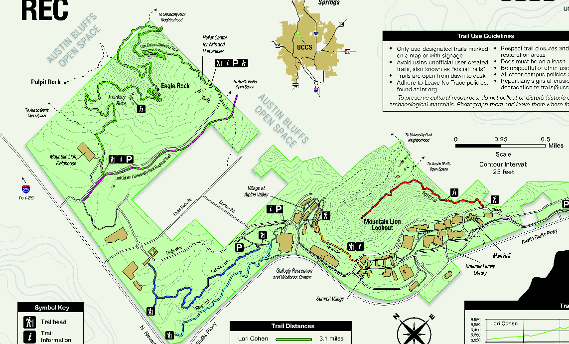
Lori Cohen Memorial Trail Moderate
Distance
3.1 mi
3.1 mi
Est. Time
~1 hr 30 min
~1 hr 30 min
Elevation
+350 ft
+350 ft
Surface
Dirt singletrack
Dirt singletrack
Trailhead
Mountain Lion Fieldhouse (University Park)
Highlights
The longest loop on campus, winding through Austin Bluffs Open Space past Eagle Rock and Pulpit Rock with sweeping views of Pikes Peak.
ROTC Trail Hard
Distance
0.6 mi
0.6 mi
Est. Time
~35 min
~35 min
Elevation
+250 ft
+250 ft
Surface
Dirt
Dirt
Trailhead
Stairway behind Main Hall
Highlights
A short but steep climb to Mountain Lion Lookout, passing remnants of a 1986 ROTC-built fitness course.
Tuckahoe Trail Easy
Distance
0.7 mi
0.7 mi
Est. Time
~20 min
~20 min
Elevation
~60 ft
~60 ft
Surface
Dirt
Dirt
Trailhead
Near Clyde Way / Gallogly RWC
Highlights
A quiet, rolling path through ponderosa woodland linking the west-campus trails. Pairs naturally with Wikiup for a short loop.
Wikiup Trail Easy
Distance
0.6 mi
0.6 mi
Est. Time
~15 min
~15 min
Elevation
-120 ft
-120 ft
Surface
Dirt
Dirt
Trailhead
Near Gallogly RWC
Highlights
A gentle downhill through pine and shrubland — easy enough for a quick between-class walk, and connects to Tuckahoe.
Tava Trail Easy
Distance
0.3 mi
0.3 mi
Est. Time
~10 min
~10 min
Elevation
+40 ft
+40 ft
Surface
Dirt
Dirt
Trailhead
Summit Village / Gallogly RWC
Highlights
The shortest trail on campus, named for Tava — the Ute name for Pikes Peak. A quick nature break beside student housing.
University Park Regional Trail Easy
Distance
Connector
Connector
Est. Time
Varies
Varies
Elevation
Rolling
Rolling
Surface
Crusher fines
Crusher fines
Trailhead
Lori Cohen / University Park
Highlights
A regional connector linking campus to the University Park neighborhood and the wider Austin Bluffs Open Space trail network.
Difficulty: Easy Moderate Hard
Trail Etiquette & Safety
Stay on Designated Trails. Only use trails marked on the map or with signage.
Dawn to Dusk. Plan your route so you finish before dark.
Leash Your Dog. Pack out what your pet packs in.
Leave No Trace. Pack out all trash and respect other trail users.
Protect the History. Photograph artifacts and leave them where you find them.
Report Damage. Email erosion or trail damage to rwong2@uccs.edu